


Le Plan sans boue fait 2022

pidjam
User
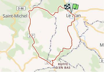

Length
9.8 km

Max alt
367 m

Uphill gradient
165 m
Km-Effort
12 km

Min alt
258 m

Downhill gradient
166 m
Boucle
Yes
Creation date :
2022-01-13 13:25:11.817
Updated on :
2022-01-13 15:43:15.93
2h17
Difficulty : Medium

FREE GPS app for hiking
 SityTrail
IGN / Geographical institutes
SityTrail Plus
The world is yours!
About
Trail Walking of 9.8 km to be discovered at Occitania, Haute-Garonne, Le Plan. This trail is proposed by pidjam.
Positioning
Country:
France
Region :
Occitania
Department/Province :
Haute-Garonne
Municipality :
Le Plan
Location:
Unknown
Start:(Dec)
Start:(UTM)
347101 ; 4781207 (31T) N.
Comments